Fellow Extravaganzers:
Mid- May and now mid-runoff, inasmuch as you haven’t had many (?!?) emails from me this week, I thought I would take a moment, mid-flow, to give you a detailed report and my unofficial take on “where we are and where we are heading” runoff-wise this year.
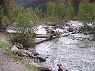
Attached are two picture taken my Your Hostess With The Mostess the best tell the tale that “the tide is, indeed, a-risin’” along Rock Creek and its sister Western Montana rivers. Compare these shots with those taken a week ago on May 12th and you can see the visual effect that the runoff has had on our home river.
This week has seen cooler weather in the Missoula area (with nightly lows in the 30’s and 40’s) and, resultantly, the attached flow chart shows their slowing impact on the runoff. Most of the snow that is melting off/to be melted off is at the 6,000-8,000 elevation level. The current forecast for the Missoula area (see the weather link on Der Blog for up to the minute details) is for temperature highs to be in the mid to high 60’s for the balance of May, with a spike into the 80’s a week from now. With temperatures declining at the rate of 3 degrees per additional 1,000 feet in elevation, that means that daytime temperatures at the targeted snow levels should consistently be from 51 to 58 degrees, with nighttime lows dipping into the 30’s and rain predicted in Missoula for more than half of the remaining May days, while there may be daytime runoff at the higher climes there may be the addition of new nighttime snow, adding to the runoff burden.
As the redline in the flow chart on Der Blog’s right sidebar reflects, the flow is directly tied to the ambient temperatures. We had a consistent warming spell during the early part of May (which is reflected by the meteoric rising runoff redline between May 5th and May 16th) and, then, as temperatures dropped the flow has correspondingly followed the last two days (reflected by the redline drop in the attached chart). If the weather forecast holds (and that is a mighty large presumption, as the only truly accurate micro-climate-filled MT weather forecast is that which happened to you where you were 15 minutes earlier), we should see a steady rise in our redline barometer.
There still is a lot of snow in the upper climes to melt and come downhill, gang; in fact, graphically, there is twice the amount of snowpack as last year (the green line) such that our 2011 redline has to eventually account for twice the amount of water as last year.
My prediction? Based on all that I learned about water flow in law school 40 years ago, Rock Creek Ron’s prediction is that we will continue to have a classic healthy 2011 runoff and that a month from today (Group One’s first fishing day) the flow will have peaked the week before and declined to a (very fishable) 1850 cfs come June 19th.
We shall see what we shall see, however, and, (as you [very seasoned] Group One and Group Two veterans remember from the high water year of 2008), REGARDLESS OF THE WATER CONDITIONS WE WILL FISH EACH AND EVERY DAY OF 1E-11…our back up plan, if necessary, is, just as we did in E-08, to get up a bit earlier and travel over the Continental Divide and fish the marvelous Missouri River and, again as we did that year, load up our Twenty Inch Club roster with a gaggle of gorgeous mega-trout!!
May the flow be with you—it will be fun to watch this year’s show unveil itself in the days and weeks ahead.
Rock Creek Ron
---<’///><


No comments:
Post a Comment